Sunday, June 27 (72Km, 2251m)
After a delicious breakfast of muesli and yoghurt and bread and cheese, I received a call from my friend Chip, who was scheduled to meet us in Andermatt in the evening. His flight from Boston had just landed in Milan, but his bicycle somehow wasn't aboard. He would need to wait at least a day to retrieve it. Disappointed but trying to make the best of the situation, I gave him my cousin Tommaso's address and phone number and suggested that he make himself comfortable in Milan.
We set off late under cool, partially overcast skies: back up past the Aareschlucht, through Innertkirchen, and up the Grimselpass road. After a handful of wooded switchbacks the road opens up to reveal magnificent views of the Haslital. This valley is a small Swiss Yosemite: enormous granite walls so smooth and steep that they retain no snow, and many rock climbers. This being a Sunday, I counted 19 people on one broad rock face alone.
My favorite part of the climb is just after the small village of Handegg, where cyclists must take the old road to avoid a steep 1Km-long tunnel. The old road is narrow and cobblestoned: it leaves the new one under an impressive rock overhang, and affords great views of the valley and the Aare River. Not long after the turnoff we met a group of people in wetsuits and climbing harnesses. They were planning to rappel down the cliff into the river, and then somehow kayak downstream!
From there it was an easy climb to the lower of the two artificial lakes operated by the KWO/Grimselstrom hydroelectric facility, and then up another handful of switchbacks to the second lake. The water level was very low, and the Grimsel Hospiz, a mountain hotel on the shores of the upper lake, towered atop a hill that is usually submerged.
We reached the summit (2165m) among the deafening roar of many motorcycles. After obligatory photos of the frozen summit lake and of the vertiginous switchbacks on the south side of the pass, we sped down those same switchbacks to the hamlet of Gletsch (1760m) for lunch. The ramps between switchbacks on this road are long and steep, and I frequently exceeded 70Km/h before pulling hard on the brakes to make the next turn. I arrived at the bottom exhilarated and with tears streaming from my eyes.
Lunch was a simple tomato spaghetti affair in a large, bustling hall attached to the Hotel Glacier du Rhône. A live band reinforced Swiss national sterotypes with jovial but silly "um-pa-pa um-pa-pa" tunes (Hans, Thomer, and I concluded that the singer was probably drunk). The price was Swiss too: SFr 90 (approximately $72 at current exchange rates) for three plates of pasta!
Grey clouds hid the sun as we headed up Furkapass. Many fast cyclists with no bags or panniers were out for a ride, and I increased the pace to ride with one of them. But after a few minutes I slowed down again to rejoin Hans and Thomer and take some photos of the fantastic scenery around us. The rock wall of the Rhône glacier rose to our left, and to its right the Furka road zig-zagged up the mountain face and ultimately disappeared from sight.
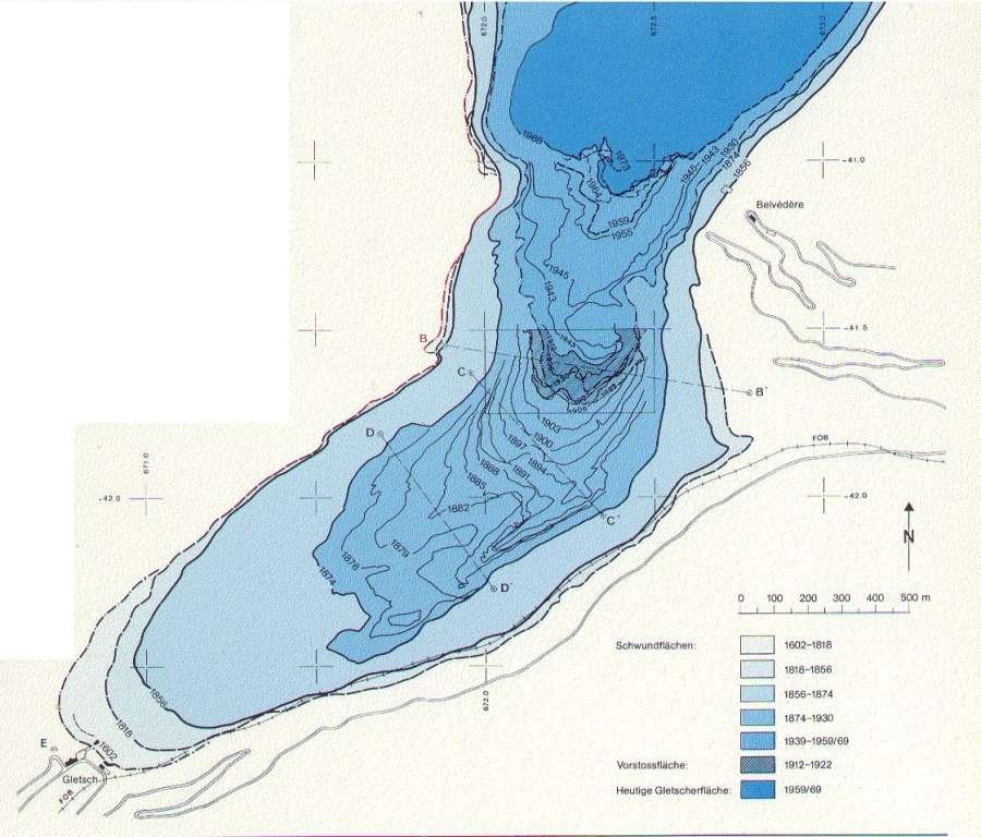
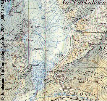
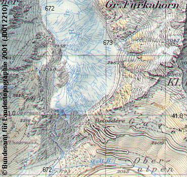
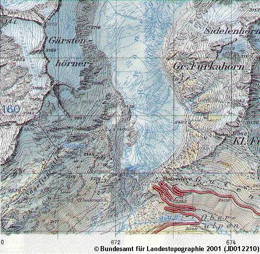
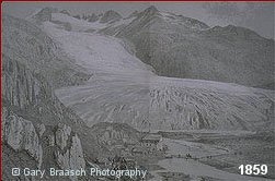
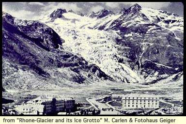
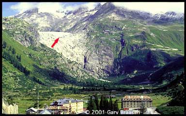
After a short steep section we reached the Hotel Belvedere, ideal vantage point for viewing the glacier. Unfortunately, the Rhône glacier is frequently cited as an example of glacial retreat in the Alps, and it has seemed smaller each time I've seen it. This year it was a small tongue of ice at the bottom of a much larger lateral moraine. You may want to compare a photo from this year with one taken on Jobst Brandt's 1976 tour of the Alps. Admittedly, the perspective is very different, but so is the amount of ice. If you are interested, take a look at a diagram of glacial extent from 1602 to 1973, or topographic maps of the region produced by the Swiss Federal Institute for Topography (Bundesamt für Landestopographie) in 1960, 1986, and 1993. (I obtained all this data from the European Earth Observation website.) And here is the glacier as seen from Gletsch at 71-year intervals: 1859, 1930, and 2001.
I ruminated on the lack of political will to address global warming seriously, but as we climbed further the scenery swept all these thoughts from my mind. The sun had broken through the clouds in places, lighting up the snowfields of the Bernese Alps in the distance and creating an ever-changing patchwork of light and shadow in the valley below. So beautiful! Hans continued slowly upward while Thomer and I stopped to admire the scene several times. I took a few photos, well aware that they would never convey the grandeur of what lay before us.
We stopped for photos on the Furka summit (2436m), and then plunged down the 1000-meter descent to Andermatt. Conditions were perfect, and I really opened up the gas, spinning out in my 50x12 on the straight sections and hitting both brakes hard as I approached turns. On these narrow and windy roads bicycles have an enormous speed advantage over cars: I passed many cars and stayed ahead of them despite stopping to take photos. I waited for Thomer and Hans in Realp, and together we covered the long straight descent to Hospental and then the last few kilometers to Andermatt at a brisk pace.
We had planned to stay in Andermatt because in the morning Hans needed to cycle back to his car in Altdorf to drive back to Germany, while Thomer and I would be riding over St. Gotthardpass into Ticino. As we pedaled around town to find a hotel, Hans' front wheel wedged into a rut between two rows of cobblestones and he went down hard on his right elbow. But fortunately it was nothing serious: the local military infirmary confirmed that there were no fractures and sent Hans home with a bandage without charging anything. We checked into the Hotel zur Sonne, where the lady running the restaurant, sensing my abundant appetite, assured us that she would bring a "militär Portion" of spaghetti. She kept her promise, and after an equally abundant coupe of ice cream and a bit of Euro 2004 soccer (Czech Republic 3 - 0 Denmark), we were all fast asleep.